|
Bench marks
|
 |
 |
|
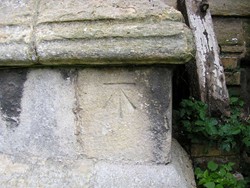
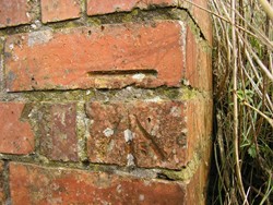
Bench marks on St Andrew’s Church at Billingborough (left) and
on the brickwork of a drainage culvert in Aslackby fen. |
A bench mark is an Ordnance Survey
arrowhead sign found on stationary objects such as walls, bridges,
churches and specially erected concrete posts where the altitude above sea
level has been accurately measured by surveyors and may be used as a
reference point in tidal observations and surveys.
The arrowhead points to a horizontal line above it which marks the exact
altitude. At places below sea level, the arrowhead points down.
The marks are charted on the large-scale Ordnance Survey maps, such as the
6 in. and 25 in. to the mile.
When a surveyor takes another altitude measurement from the mark, an
angle-iron is fixed at the level of the horizontal bar to form a temporary
bracket or “bench” which supports the levelling instrument.
Bourne lies between fen and upland and
therefore has a varying elevation above sea level. The ridge of Jurassic
land which lies to the west overlooks the town with the reclaimed fen to
the east but the area is not one of great altitude, rather a very gentle
relief, the fen edge being at a height of about 23 feet while 1½ miles
away, the highest ground in Bourne Wood is at about 190 feet. The town
itself is built mainly between the 25 ft. contour line on the east side
and the 50 ft. contour line on the west.
Bench marks may be found in the Bourne area but few survive in the town
itself because of modernisation and drastic alterations to old properties.
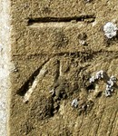
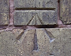
There is a bench mark on the Abbey Church
and it can be found at the foot of the tower on the southern face while
one of the dark lines high up on the stonework is reckoned to have been
left by the flooding in November 1571. The locality was hit by one of the
worst storms in history and it was later recorded that the flood water in
Bourne rose "to midway of the height of the church walls" during a tempest
which affected the whole district, particularly houses and other buildings
on the eastern side of the town.
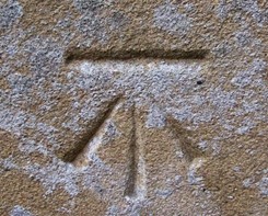
Two others can be found on the front of the
cemetery chapel in South Road and on the yellow brickwork of the
commercial premises of No 2 South Street.
|
 |
 |
 |
|
Bench marks on the Abbey Church (left), the
cemetery chapel (centre) and at No 2 South Street
(right). |
Other known bench marks are on the Town
Hall, a private house at 101 on the west side of North Road and at the Abbey Primary School,
all flush brackets. A flush bracket on the lodge house at Bourne Hospital
in South Road disappeared when the premises were demolished in the summer
of 2003.
|
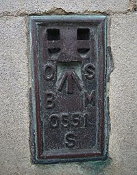
Flush Bracket S0551:
Bourne, Town Hall W face, SW angle of Town Hall, E side of Market
Place - 34.852' [Stamford to Holbeach]; [3GL] - NE side of junction
A151 and A15, middle of Bourne.
- official listing of the Town
Hall bench mark by Ordnance Survey
|
 |
The level shown for the old Market Place, now the town centre, on the 1891
OS map shows 34 feet above sea level and there is a flush benchmark on the
Town Hall nearby.
The other nearest benchmarks to the centre of the town shown on this same map
are on the old railway bridge which crossed the Abbey Road east of the
primary school, in West Street and in North Road on land where Wherry’s
windmill once stood, now the junction with Mill Drove. All have
disappeared. Known bench marks in Bourne:
1. Woodland Nurseries off
Exeter Street now demolished (incised mark)
2. No 69 Woodview (incised mark)
3. Building on the east side of Exeter Street (incised mark)
4. No 63 West Street (incised mark)
5. No 35 Woodview (incised mark)
6. No 43 Stanley Street (incised mark)
7. No 17 Woodview (incised mark)
8. No 2 South Street (incised mark)
9. Wake House, North Street (incised mark)
10. The Town Hall (flush bracket)
11. No 14 North Road (incised mark)
12. No 4 Harrington Street (incised mark)
13. No 1 Queen's Road (incised mark)
14. No 35 Queen's Road (incised mark)
15. No 1 Recreation Road (incised mark)
16. No 53 Recreation Road (incised mark)
17. No 46 Harrington Street (incised mark)
|
THE LEGAL STANDING OF BENCH MARKS
There is no specific legal protection for bench
marks. It was always assumed that there would be losses from
redevelopment work and the subsequent demolition of buildings and so
a redundancy was built in. OS would not be greatly concerned with
the loss of a specific mark, especially today when most are no
longer in use, although it would be better if they were preserved.
OS used to collect any flush brackets from buildings due to be
demolished whenever they were informed of the impending loss
although this was more of a courtesy than a legal requirement. Some
bench marks on triangulation pillars are still actively used as part
of the GPS passive network. For example, flush bracket S8696 on the
trig at Pickworth, near Bourne, carry a plate warning that it is an
offence to damage the pillar.
- statement from Ordnance Survey, Wednesday
7th February 2007 |
See also
Flooding in Bourne

Go to:
Main Index Villages
Index
|


